Tropical Plant Research
An International Journal by Society for Tropical Plant Research
Useful Links
Abstracted and Indexed
Identifier

2015, VOLUME 2 ISSUE 2Pages: 101-107
Assessment of land use land cover change in Chakrar watershed using geospatial technique.
Sandeep Soni*, P.K. Garg, Ashutosh Singh and Abhishek K. Maurya
Abstract:
Rapid urbanization, anthropogenic and socioeconomic activities and environmental changes, in local and regional area, are important component responsible for extensive land use land cover changes (LULCC). Now a day, it is important to determine LULCC at appropriate scale to determine impacts of above mentioned components. In this study an attempt has been made to analyze LULCC in the Chakrar watershed, Madhya Pradesh which is an important tributary of the Narmada River. The watershed is covered by natural forest that is out skirt forest of Achanakmar-Amarkantak Biosphere reserve of Central India. A series of systematically corrected orthorectified Landsat imageries of 1990, 2000, 2005, 2011 and 2013 were used for classification. Geospatial technique was used to assess LULCC and accuracy assessment was also done. It was obtained that natural forest cover decreased by 24.11 Km2 and human settlement increased by 7.78 Km2. Therefore, the study was important to assess the loss in natural vegetation that can affect natural biodiversity, ecology and biosphere reserve including environment.
Rapid urbanization, anthropogenic and socioeconomic activities and environmental changes, in local and regional area, are important component responsible for extensive land use land cover changes (LULCC). Now a day, it is important to determine LULCC at appropriate scale to determine impacts of above mentioned components. In this study an attempt has been made to analyze LULCC in the Chakrar watershed, Madhya Pradesh which is an important tributary of the Narmada River. The watershed is covered by natural forest that is out skirt forest of Achanakmar-Amarkantak Biosphere reserve of Central India. A series of systematically corrected orthorectified Landsat imageries of 1990, 2000, 2005, 2011 and 2013 were used for classification. Geospatial technique was used to assess LULCC and accuracy assessment was also done. It was obtained that natural forest cover decreased by 24.11 Km2 and human settlement increased by 7.78 Km2. Therefore, the study was important to assess the loss in natural vegetation that can affect natural biodiversity, ecology and biosphere reserve including environment.
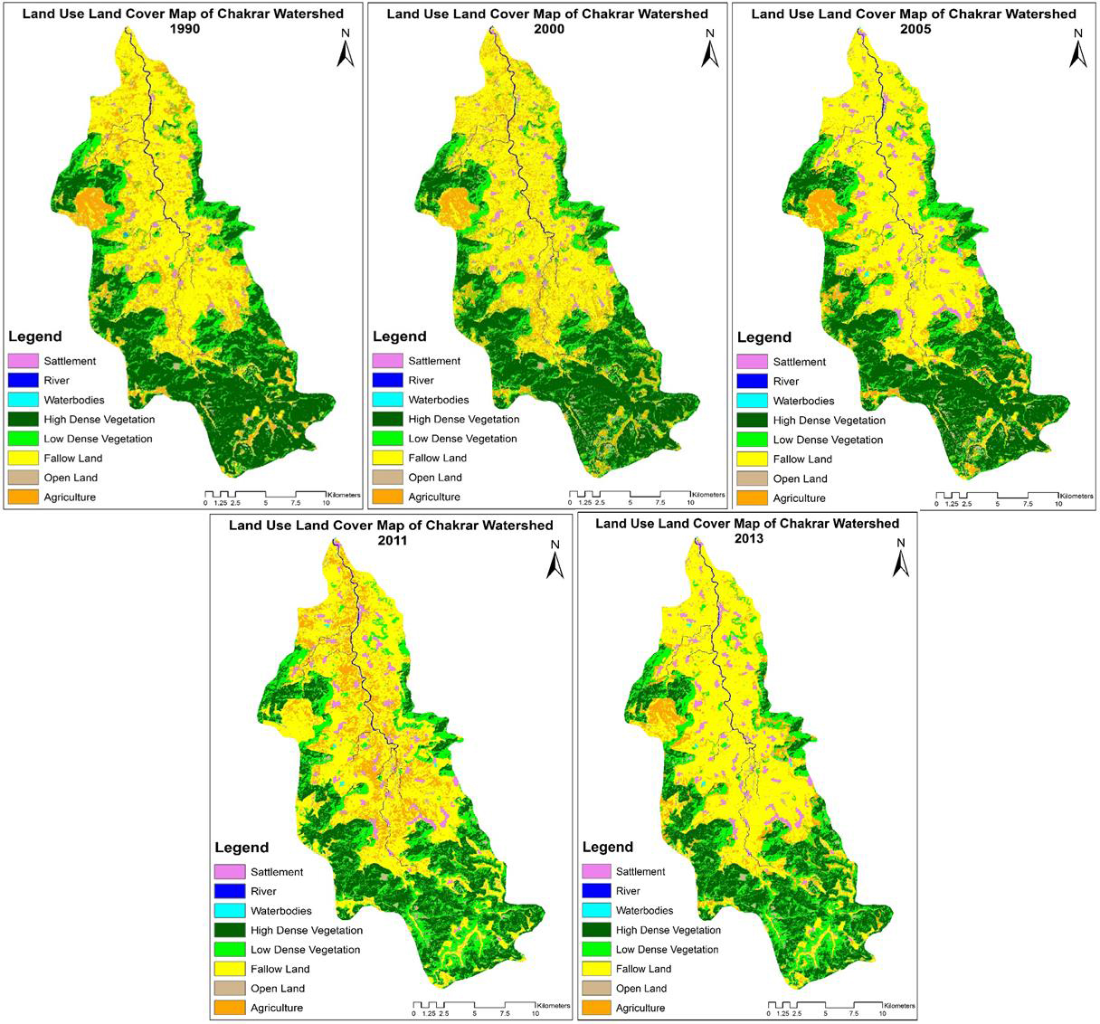
Fig.: Assessment of Land use Land cover Change in Chakrar Watershed using Geospatial Technique.
Useful Links
Abstracted and Indexed
Identifier
| 0 | 1 | 2 | 5 | 5 | 6 | 3 | 1 |